
There are more places on Earth than we can keep track of.
Just think about all the residences, national parks, businesses, bodies of water … I could go on.
Geocoding is the process of turning a description of a location, such as its physical address, into a precise location on a map, namely, a pair of coordinates.
For businesses concerned with different locations, keeping track of a variety of physical locations can be a daunting task. Geocoding helps to make it a little more manageable.
Many geographic information systems - or GIS software - perform geocoding functions. The ability of GIS, GIS mapping, and location intelligence to utilize spatial data also makes it beneficial in the geocoding process.
This process relies on a computer representation of those addresses, as well as roads, and postal/administrative boundaries. Geocoding one or multiple locations will output geographic features with specific attributes that can be used for spatial analysis.
Geocoding allows businesses to quickly access various types of locations vital to their business. Geocoding software also enables users to reverse geocode, which is the process of converting geographic coordinates to physical addresses.
Geocoding goes beyond simply providing a long list of coordinates to businesses. Coordinates are actually pretty powerful and can benefit businesses in a variety of fields. The following are just a few of the benefits geocoding offers.
Geocoding addresses displays those locations on a map. By geocoding enough addresses within a small enough vicinity, users will begin to recognize different patterns. This ability is a boon for businesses, from law enforcement officers analyzing crime in a certain neighborhood to environmental scientists studying a changing landscape.
Customer data is incredibly valuable for basically every business. Thanks to geocoding, a user can map their customers’ locations. This can help those businesses develop targeted marketing strategies for specific clusters of customers.
Local government officials can utilize geocoding technology to analyze address data. These users can track population growth in a certain area and use the information in a number of ways, such as helping decide whether to build a new school to account for population growth.
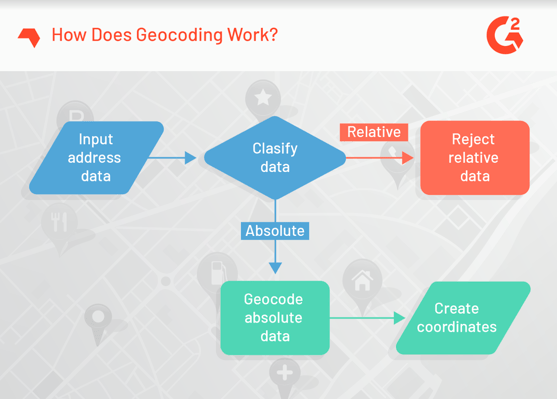
The two main geocoding components are the reference data set and geocoding algorithm. Beyond that, the process can vary slightly, but it should generally follow the steps below.
1. Every geocoding process begins with the input data. This is the list of addresses you would like to have geocoded. Users start the geocoding processes by inputting this data set.
2. Input data is subsequently classified into either relative input data or absolute input data.
a. Simply put, relative input data are addresses that aren’t specific enough to geocode. An example might be “the building across the street from the White House.” Geocoding cannot be accomplished with a location this vague.
b. Absolute input data is geocoded and turned into a list of coordinates.
3. Absolute input data is geocoded and turned into a list of coordinates.
As previously mentioned, geocoding is a common functionality within GIS software. GIS enables users to visualize, analyze and interpret geographic data. The data can then be used to interpret trends and recognize patterns in a specific region.
Data quality software can also perform geocoding. These programs analyze a set of information and identify incorrect or incomplete data, ensuring a user’s business data set is clean. The following software products were selected due to their distinct ability to help users geocode.
 G2 Crowd star rating: 4.6 out of 5.0 stars (17 reviews)
Overview: This software is designed to assist any business of any size in need of location-related information. Loqate GBG offers a combination of address verification and geocoding technology to provide businesses with a rich data set. This program applies to more than 245 countries.
Features:
Allows users to check their address data against a global portfolio of databases
Available global application programming interface (API) to ensure data is displayed in the best way for your business
This software can be used on-premise or in conjunction with a public or private cloud — whichever way is most suitable for your business.
Pricing: Contact the vendor with pricing inquiries
What users like:
“The fact that it runs quickly and returns consistent data, and can be integrated into a number of platforms.”
— Loqate, a GBG solution review by Alex P.
What users dislike:
“We occasionally had inaccurate data but are in a small location.”
— Logate, a GBG solution review by Richard L.
Recommendations to others considering the product:
“Start with a trial (DEMO mode) — you will notice value fairly quickly (or not). It’s an easy purchase if you see the value.”
— Logate, a GBG solution review by an agency in marketing and advertising
 G2 Crowd star rating: 4.5 out of 5.0 stars (1 review)
Overview: This program offers iOS users a wide range of mapping and GIS capabilities online or offline. Capabilities include data visualization, routing, editing and more.
Features:
Geocodings
Web map management
Mobile map packages
Vector-tiled layers
Pricing: Contact the vendor with pricing inquiries
What users like:
“ArcGIS have provided awesome support for the GIS environment in the mobile. ArcGIS has provided a good contribution to the touch screen devices specially for IOS.”
— ArcGIS Runtime SDK for iOS review by Chetan C.
What users dislike:
“Their pricing is high. Platform should be open source and free same as that of QGIS.”
— ArcGIS Runtime SDK for iOS review by Chetan C.
 G2 Crowd star rating: 3.0 out of 5.0 stars (1 review)
Overview: This software holds all the address information your business needs. It lets users clean up and standardize their records to improve overall data quality.
Features:
Cleans and augments customer data
Can source data from anywhere in the world
Helps users ensure customer information is accurate
Pricing: Contact the vendor with pricing inquiries
What users like:
“SAP Address Directories is intuitive and flows appropriately as you navigate through the menus.”
— SAP Address and Geocoding Directories review by a user in mechanical or industrial engineering
What users dislike:
“While the flow is intuitive, I do not like the user interface.”
— SAP Address and Geocoding Directories review by a user in mechanical or industrial engineering
Recommendations to others considering the product:
“SAP Address directories has allowed me to have faster access to needed addresses.”
— SAP Address and Geocoding Directories review by a user in mechanical or industrial engineering
 G2 Crowd star rating: N/A
Overview: Spectrum Enterprise Geocoding allows users to accurately locate, geocode and enrich data for the most precise and focused business insight possible. This tool lets businesses add context to their data thanks to a wide range of existing datasets available for use.
Features:
Data available for any location in Canada, Australia and the U.S.
Allows users to correct errors in addresses with precision
Able to distinguish street addresses from information such as postal codes
Pricing: Contact the vendor with pricing inquiries
Be the first to leave a Spectrum Enterprise Geocoding review!
 G2 Crowd star rating: N/A
Overview: Geocodio is a user-friendly and affordable geocoding solution. With this product, users can geocode, reverse geocode and enhance data for U.S. and Canadian addresses. Geocodio is equipped to process small or large data sets.
Features:
Can automatically add missing components to an address and sort complex addresses
Fast and accurate, the program geocodes data sets of any size
Can automatically correct typos
Pricing: Contact the vendor with pricing inquiries
Be the first to leave a Geocodio review!
*Some reviews have been edited for grammar
**Data as of January 14, 2019


Thanks to the ever-growing digital landscape, communication doesn’t always occur in a physical...
 by Tricia Dempsey

In the time it takes to read this sentence, tens of thousands more tweets will have been...
 by Andrew Zangre

Gaining visibility on leads, tracking agent performance and activity, centralizing operational...
 by Jasmine Lee